The Sayano-Shushenskaya Dam: a concrete arch in the Yenisei canyon
How an arch-gravity dam blocked the Yenisei in the Sayan Mountains and created a reservoir more than three hundred kilometres long.
Cultural feature · checked 5 October 2026 · 5 min read
Published 5 October 2026
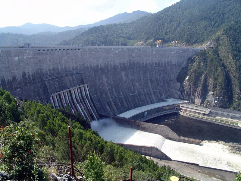

Where the Yenisei leaves the Sayan Mountains, its bed is blocked by a pale concrete wall curved against the current. This is the dam of the Sayano-Shushenskaya hydroelectric power station near the settlement of Cheryomushki, close to Sayanogorsk in Khakassia. Above it presses a man-made sea stretching hundreds of kilometres upstream, while below it water bursts out after giving up its strength to the turbines. From here the crest looks like a thin line drawn between the canyon walls.
The station is remarkable not only for its capacity: ten generating units of 640 megawatts each, 6,400 megawatts in all. Its dam belongs to the rare arch-gravity type, relying on its own weight while also, like an arch, passing the pressure of the water to the rocky banks. The complex took more than two decades to build, and its reservoir changed the face of a whole stretch of the Sayan Mountains. The station's story is one of engineers working with a river, with rock and with a mountain climate.
The Karlov site
The decision to build a station on the Yenisei was taken in 1960, and on 4 November 1961 surveyors arrived at the future construction site. According to the Sayano-Shushensky branch of Siberian Federal University, the first survey party was led by Pyotr Vasilyevich Yerasov. The site chosen for the dam was the Karlov alignment, a stretch where the river cuts through the mountains in a narrow canyon. Its banks are made of strong bedrock on which a heavy structure can rest.
The design was produced by the Lenhydroproject institute, and construction began in 1963. Next to the site grew the settlement of Cheryomushki, home to the dam builders and today to many of the station's staff. The local university branch still trains engineers for the plant, and its graduates go on to work in various departments of the station. Around a single structure there thus grew both a town of power engineers and an engineering school of its own, tied to the Yenisei.
An arch that holds on to the rock
The dam is about 242 metres high (some sources give 245 metres), and its crest is between 1,066 and 1,074 metres long, depending on the source. It is about 105 metres wide at the base and 25 metres wide at the crest. Around 9 million cubic metres of concrete went into the structure, and its mass reaches roughly 20 million tonnes. It is described as one of the tallest and longest dams of its type in the world.
The secret of the design lies in sharing the work. According to encyclopedic sources, about 60 per cent of the water's thrust is absorbed by the dam's own weight, while about 40 per cent is carried through the arch to the rock of the banks. The body of the dam is divided by construction joints into 68 sections, and it stands on strong schist bedrock. According to the Znanie encyclopedia, the structure is designed to withstand earthquakes of up to eight points on the seismic intensity scale.
A quarter-century of construction
The Yenisei was closed off at the site on 11 October 1975, and the first generating unit started work on 18 December 1978. The tenth unit came on line on 25 December 1985, but work on and around the dam went on for a long time afterwards: construction was officially declared complete in 2000. The station's average annual output is about 23.5 billion kilowatt-hours. The maximum head under which the turbines operate is roughly 220 metres.
The station releases surplus water through an operational spillway in the body of the dam; below it the flow is calmed in a stilling basin almost 145 metres long. On 17 August 2009 a major accident occurred at the plant, killing 75 people. The station resumed operation in February 2010, a shoreline spillway of two tunnels, each 1,130 metres long, was commissioned in 2011, and the restoration of all units was completed in November 2014.
The Sayan Sea
The reservoir was filled between 1980 and 1987. It covers 621 square kilometres and holds about 31.3 cubic kilometres of water in total, of which about 15.3 cubic kilometres is usable storage. According to Vokrug Sveta magazine, it stretches 312 kilometres along the Yenisei valley, and its greatest depth reaches 220 metres. Over a year the water level can change by almost 40 metres.
The new sea transformed life in the valley. Around 489 square kilometres of forest were flooded when it was created, the town of Shagonar and the village of Chaa-Khol were moved, and many archaeological sites ended up under water; some are studied in May and June, when the water level drops. The Sayano-Shushensky Nature Reserve lies on the reservoir's shores, where scientists observe snow leopards and reindeer whose groups the reservoir has separated.
Sources & context
- Znanie Encyclopedia — Sayano-Shushenskaya HPP
- Sayano-Shushensky Branch of Siberian Federal University — history of the Sayano-Shushenskaya HPP
- Construction of Unique Buildings and Structures (SPbPU) — paper on the Sayano-Shushenskaya dam
- Vokrug Sveta — Life by the new sea
- Wikipedia — Sayano-Shushenskaya Dam
A russia.direct editorial selection based on open sources. Checked 5 October 2026. Practical suggestions are a decision guide, not a promise of outcomes.
Editorial principles