Elbrus: a sleeping volcano under an ice cap
Two summits, ancient lavas and glaciers that glaciologists have measured for decades: how the highest mountain in the Caucasus and Russia is built.
Cultural feature · checked 5 October 2026 · 5 min read
Published 5 October 2026
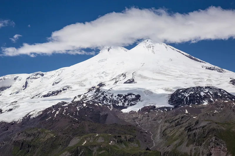

On a clear day Elbrus can be seen from far away: above the jagged ridges of the Caucasus rises a white, twin-humped mass quite unlike the sharp peaks around it. The western summit reaches 5,642 metres, the eastern 5,621 metres, and the saddle between them lies at about 5,416 metres. The mountain stands on the border of Kabardino-Balkaria and Karachay-Cherkessia, some 11 kilometres north of the Main Caucasus watershed. It is often called the highest peak in Europe and is counted among the world's Seven Summits.
The soft outline of Elbrus gives away its origin: it is not a folded mountain but a dormant stratovolcano built of layers of lava and ash. Its slopes carry one of the largest glacier systems in the Caucasus, which feeds the Baksan, Kuban and Malka rivers. For scientists Elbrus is a natural laboratory where they can study both the history of eruptions and the way the climate is changing. In the Karachay-Balkar language the mountain is called Mingi-Tau, the eternal mountain.
A volcano asleep
According to geologists, Elbrus began to form more than 2.5 million years ago, and its main caldera appeared about 700,000 years ago. The eastern summit still keeps a well-preserved crater. The last major eruption, according to the Institute of Geography of the Russian Academy of Sciences, took place in the first or second century AD, and weaker activity was recorded about 900 years ago. That is why the volcano is considered dormant rather than extinct.
Traces of past activity can be seen on the slopes: ancient lava flows and deposits of volcanic mudflows, which volcanologists study in their own right. Heat from the interior can still be felt today, if only faintly. Glaciologists calculate that geothermal heat melts the ice at the base of the glaciers only very slightly, on the order of a hundredth of a metre of water equivalent a year. Summer melting at the surface is far stronger, so the fate of the glaciers is decided above all by the climate.
The ice cap
The glaciers spread out from the summits in every direction like rays. Researchers at the Institute of Geography count 23 Elbrus glaciers, the largest being Bolshoi Azau and Irik. According to their data, in 2017 the glaciers covered about 112 square kilometres and held about 5 cubic kilometres of ice, with roughly two-thirds of that volume lying below 4,000 metres. Elbrus accounts for about a tenth of the glacier area of the Caucasus.
The Elbrus glaciers have been watched for a long time. On the Garabashi Glacier, according to the Institute of Geography, direct measurements of mass balance have been made since the late 1980s: every year glaciologists estimate how much snow built up in winter and how much ice melted in summer. Such long records are rare in the mountains and valuable because they reveal trends over decades rather than the ups and downs of single years. Satellite images and ice-thickness surveys add to them.
Twenty years of melting
In 2019 researchers from the Institute of Geography and Moscow State University published an assessment of how the Elbrus glaciers changed between 1997 and 2017. Over that period the glacier area shrank by about 11 per cent, from 125.8 to 112.2 square kilometres, and the volume of ice fell by almost a quarter. By their calculations the rate of mass loss was roughly three times higher than in 1957–1997. Mass loss was recorded on all glaciers below 4,500 metres.
The researchers see the main causes in warming, with summer air temperatures up by 0.5–0.7 degrees over 30 years, and in more incoming solar radiation. Retreat rates vary noticeably from glacier to glacier and depend, among other things, on which way the slope faces. According to the scientists, the Irikchat Glacier lost almost half its volume in twenty years and may disappear within the coming decades. The shrinking of the glaciers also matters for the rivers they feed.
Ice in the crater
Glaciologists work at the very top of Elbrus too. In 2009 an ice core 182 metres long was drilled on the Western Plateau, from the surface down to the bedrock. In 2020 an Institute of Geography expedition climbed into the crater of the Eastern Summit, which holds a small glacier of about 0.09 square kilometres and up to 100 metres thick, and recovered a core about 96 metres long, again reaching the bed.
The layers of such ice preserve snow that fell over decades and centuries, and with it a record of what the climate was like in the past. Measurements in the crater showed a temperature of about minus 0.6 degrees at the glacier bed, noticeably warmer than on the Western Plateau, and a slightly higher heat flow. The mountain's scientific story goes back a long way: the eastern summit was first reached on 10 July 1829, during a scientific expedition, and the western one in 1874.
Sources & context
- Frontiers in Earth Science — Volume Changes of Elbrus Glaciers From 1997 to 2017 (Institute of Geography RAS)
- Ice and Snow (IG RAS) — Glacioclimatological investigations in the crater of the Eastern Summit of Elbrus in 2020
- Interfax — Melting of Elbrus glaciers tripled in twenty years
- Wikipedia — Mount Elbrus
- Wikipedia — Prielbrusye National Park
A russia.direct editorial selection based on open sources. Checked 5 October 2026. Practical suggestions are a decision guide, not a promise of outcomes.
Editorial principles