Yekaterinburg: a factory on the border of Europe and Asia
How an ironworks founded in 1723 grew into a Ural metropolis, and why the best way to get to know it is to follow a red line painted on the pavement.
Cultural feature · checked 30 September 2026 · 5 min read
Published 30 September 2026
_-_2.jpg)
Many cities begin with a fortress, a church or a market square. Yekaterinburg began with a dam and factory workshops. In 1723, by decree of Peter the Great, the historian and administrator Vasily Tatishchev and the engineer Georg Wilhelm de Gennin founded a large ironworks on the Iset River, and the settlement around it was named after Empress Catherine I. The city's official birthday is 18 November 1723, the day the trip hammers were first tested in the workshops. So industry is not just part of Yekaterinburg's biography; it is its very first line.
Today it is one of the largest cities in the country: the 2021 census counted 1,544,376 residents. The city stands on the eastern slope of the Ural Mountains, very close to the conventional line dividing the continent into Europe and Asia. From 1924 to 1991 it was called Sverdlovsk, and then it took back its historical name. In 1991 a metro opened here, the sixth in Russia. But to feel Yekaterinburg's character, the best thing is not to go underground but to step out into the street and follow the red line.
Plotinka: the heart of the old ironworks
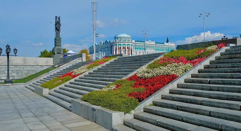
It all started with water. By November 1723 builders had put up the factory dam across the Iset in record time, and the pond that formed behind it powered the hammers and bellows. Locals affectionately call the place Plotinka, "the little dam". In the nineteenth century, during a reconstruction in the 1830s–1850s, the dam was reinforced with granite. For a long time a mint operated nearby: according to the creators of the Red Line route, for about 140 years it struck the lion's share of all Russia's copper coinage.
In 1973–1975, for the city's 250th anniversary, the grounds of the former works were turned into an open public space, the Historical Square. The relief "Birth of the City" also appeared in 1973. A water tower from the 1880s still stands on the bank, and in 1998 a monument to the founders, Tatishchev and de Gennin, was unveiled here. In summer Plotinka becomes the city's main meeting place: people come to stroll, meet friends and watch the water that once turned the wheels of the factory's machinery.
A red line on the pavement
The easiest way to explore central Yekaterinburg is to follow a red stripe painted right on the pavement. This walking route was invented and built by residents themselves: the idea was put forward in October 2010, and in April 2011 more than 11,000 locals voted online to choose the sights along the way. The Red Line officially opened on 18 June 2011. The route is a loop, so if you walk it all the way round, you end up back where you started.
According to the project, the line now runs for 9 kilometres and links 39 sights of every "weight class", from monuments and merchants' mansions to entire streets and squares. It starts on 1905 Square and passes Plotinka and the ornate Sevastyanov House, built in the mid-1860s. During the 2018 FIFA World Cup the Red Line became the city's official tourist route, and travellers on Tripadvisor ranked it first among Yekaterinburg's tours and excursions.
A capital of constructivism
In the 1920s and 1930s, during the era of industrialisation, Sverdlovsk grew at speed, and constructivism became the main language of that building boom. According to figures cited by TASS, more than 140 buildings in this style survive in the city: flat roofs, ribbon windows, bold volumes. One of the best known is the Chekists' Town, a residential complex built in 1929–1934. Its unusual feature: some of its flats had neither kitchens nor bathrooms, because everyday life was meant to be shared.
On the outskirts, in the district of the Uralmash heavy machinery plant, stands the White Tower, a water tower built in 1929–1931. It was designed by the 24-year-old architect Moisei Reisher and became the first reinforced concrete architectural structure in the Urals; its tank was the first to be joined by electric welding instead of rivets. The city also had dreams that never came true: the House of Industry was conceived as a 34-storey, 140-metre tower, but it was never built as planned.
One step from Europe to Asia
Yekaterinburg is often described as a city where two parts of the world meet, and that is easy to check. At the 17th kilometre of the Novomoskovsky Highway, within the city limits, stands the Europe–Asia obelisk, installed in 2004 to a design by the architect Konstantin Grünberg. At its foot lie stones brought from Cape Roca and Cape Dezhnev, the westernmost and easternmost points of Eurasia. You can stand with one foot in Europe and the other in Asia.
Marking this border has a long tradition in the Urals: the first Europe–Asia marker was put up as early as 1837 on Mount Berezovaya near Pervouralsk. For Yekaterinburg the line is not just a geographical curiosity but part of how the city sees itself. Grown out of a factory, it has always lived at a crossroads where roads, metal, people and ideas converged. Perhaps that is why it is so rewarding to explore on foot, from the old dam through the constructivist blocks to the symbolic line between continents.
Sources & context
- Yekaterinburg Red Line — About the project
- Yekaterinburg Red Line — Historical Square
- TASS — Constructivism in Yekaterinburg
- We Are From the Urals — The Europe–Asia border
- Wikipedia — Yekaterinburg
A russia.direct editorial selection based on open sources. Checked 30 September 2026. Practical suggestions are a decision guide, not a promise of outcomes.
Editorial principles